Fortification Architecture Style Architecture in India
This curated collection presents 11 architecturally significant heritage sites across India, each offering authentic experiences of Hindu cultural and spiritual heritage. These monuments exemplify the fortification architecture style architectural tradition, these sites spanning multiple historical periods continue serving as active centers of worship and cultural transmission. recognizing exceptional universal value. Our comprehensive documentation provides detailed visitor information, architectural insights, and cultural context, enabling meaningful engagement with India's living heritage traditions while respecting the sacred nature of these spaces.
11 Sites Found
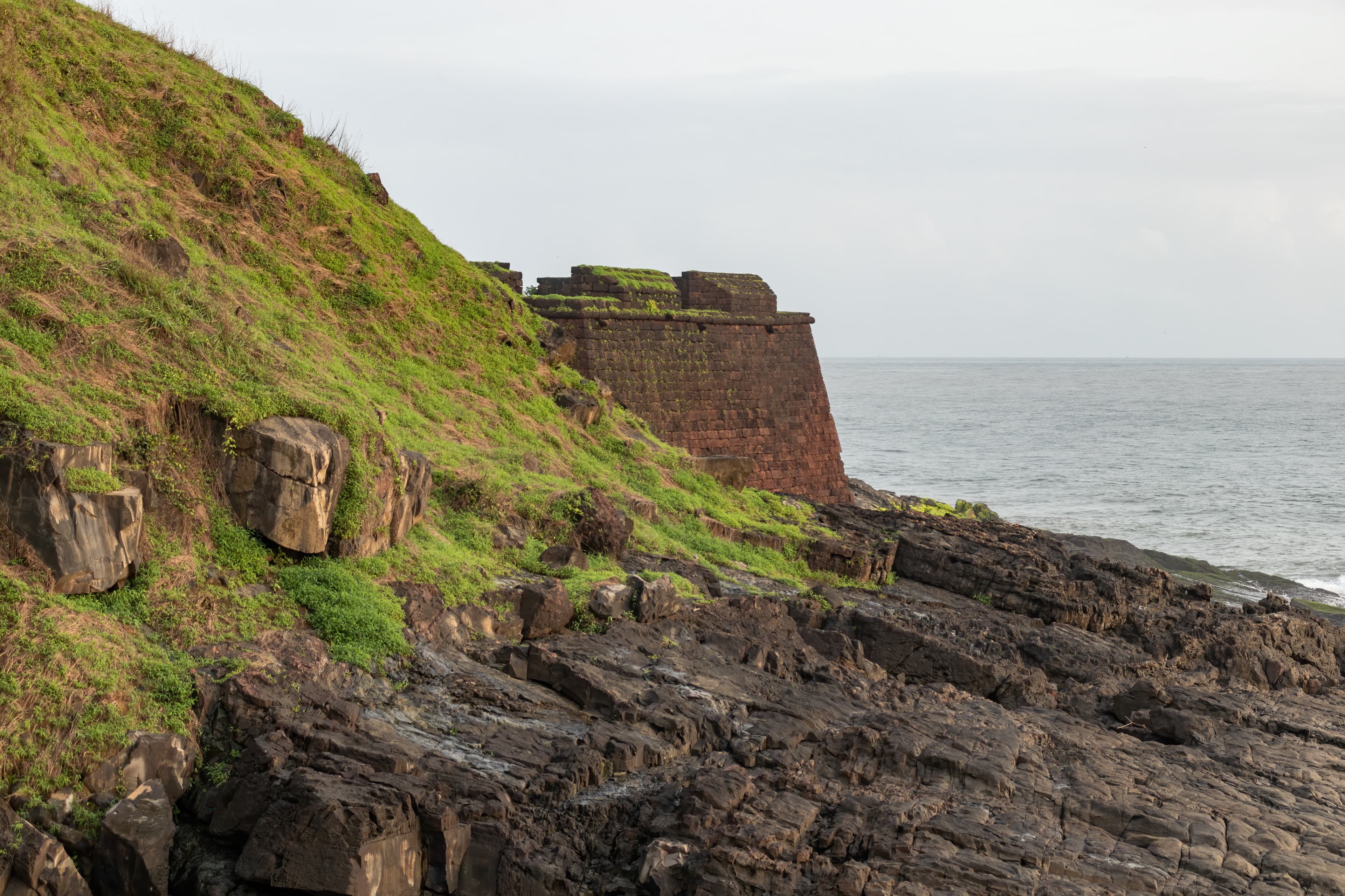
Framing Goa's coastline is Aguada Fort, a *durg* (fortress) constructed in 1650 CE by the Portuguese, strategically positioned at the confluence of the Mandovi River and the Arabian Sea ([1][2]). The fort, built with laterite stone, exemplifies a fusion of European military design and subtle Indian influences ([3]). Its sturdy lower ramparts and strategic gun placements were intended to defend against Maratha incursions ([7]). Stone platforms and foundations underscore the fort's lasting resilience. Aguada, translating to 'water', features a freshwater spring, a prime example of *jala sthapathya* (hydraulic engineering), which supplied essential drinking water to ships ([8]). Added later, the lighthouse provides panoramic vistas. It's plausible that the fort's layout integrates *Vastu Shastra* principles, aligning structures with cardinal directions to optimize defensive capabilities and spatial harmony ([9]). However, specific textual references to *Vastu Shastra* applications within the fort's design require further documented evidence. Within the *Garbhagriha* (Sanctum) of Aguada Fort, a distinct cultural synthesis takes shape. The design elements reflect the architectural and cultural exchanges prevalent during the 17th century ([1][2]). The fort's architecture doesn't explicitly mirror the intricate details described in texts like the *Manasara Shilpa Shastra* or the *Mayamata*, which extensively cover temple construction and iconography. Instead, it represents an adaptation of European military architecture to the Indian context, utilizing locally available materials like laterite and basalt ([3]). The enduring laterite walls withstand the rigors of monsoon rains and coastal conditions, demonstrating remarkable durability ([3]). Preservation efforts at Aguada allow for appreciation of its architectural integrity. Aguada Fort embodies a unique chapter in Indo-Portuguese history, a testament to the architectural and cultural interactions of the 17th century, although direct correlations to Vedic texts or specific *Shilpa Shastras* remain limited ([1][2]).
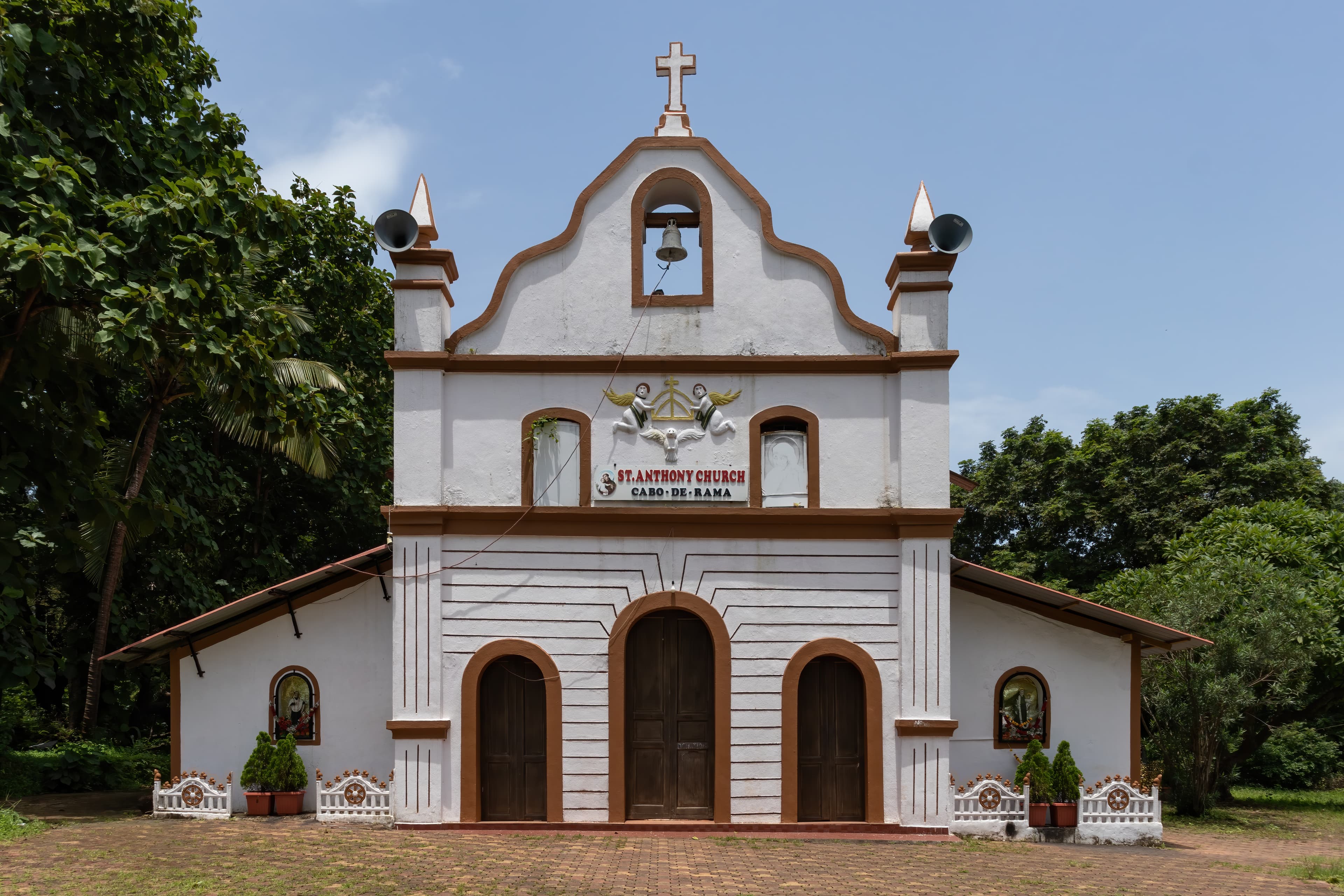
Nestled in Goa, Cabo de Rama Fort, erected around 1350 CE by the Sundara Pandya Dynasty ([1][2]), embodies a unique Indo-Portuguese architectural synthesis. This coastal fortification, unlike its more embellished inland counterparts, prioritizes strategic strength, evident in its commanding views of the Arabian Sea. The fort's construction employs laterite stone, basalt, and lime mortar ([3]), materials chosen for their durability in the coastal climate. Initially conceived with Indian architectural principles, the fort saw subsequent modifications under Portuguese rule. The remnants of barracks and a chapel ([4]) stand as testaments to this colonial influence, creating a compelling juxtaposition with the fort's earlier Indian origins. Local legends even suggest links to the epic Ramayana ([5]), adding another layer to its rich history. Such narratives often intertwine with ancient sites, reflecting the deep cultural roots embedded within the land. Strategically positioned bastions showcase sophisticated military architecture, crucial for coastal defense. Even the weathered church of Santo Antonio contributes to the site's multi-layered historical narrative. Cabo de Rama stands as a confluence of cultures and eras, seamlessly blending ancient Indian traditions with Portuguese colonialism to forge a unique architectural identity ([3][4]). This fusion exemplifies the diverse expressions of power and resilience that have shaped India's architectural landscape, leaving behind a legacy etched in stone and legend. This blend reflects the diverse expressions of power and resilience across India.
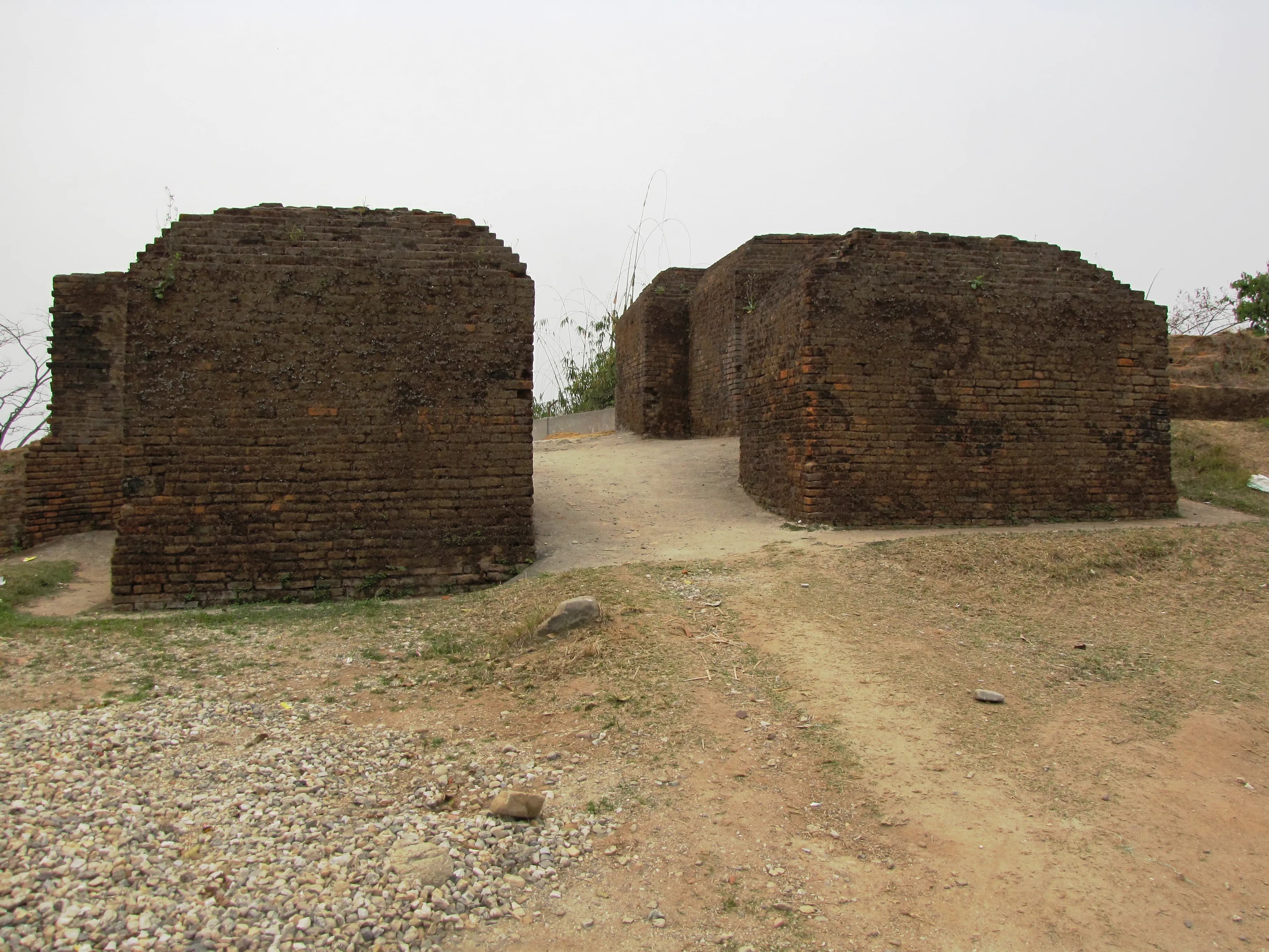
The midday sun cast long shadows across the undulating hills surrounding Itanagar, highlighting the weathered brick-red ramparts of the Ita Fort. Ascending the gentle slope towards the main entrance, I felt a palpable shift in atmosphere, a sense of stepping back in time. This wasn't merely a historical site; it was a living testament to the architectural ingenuity of the Tai-Ahom people who once ruled this region. Ita Fort, also known as the Ita Krung, isn't a fort in the conventional sense of a singular fortified structure. It's more accurately described as a fortified complex, a sprawling network of ramparts, gateways, and earthen mounds enclosing a vast area. The walls, constructed primarily of bricks, are remarkable for their sheer size and the irregular, almost organic way they follow the contours of the land. Unlike the precisely measured and geometric fortifications of the Mughals, Ita Fort displays a different kind of sophistication – an understanding of the landscape and its defensive potential. Passing through the main gateway, a modest arched opening in the thick walls, I found myself in a large open space. Here, the remnants of several structures were visible – low brick platforms, scattered fragments of walls, and the intriguing circular depressions that are believed to have been the bases of granaries. The absence of elaborate ornamentation or intricate carvings was striking. The beauty of Ita Fort lies in its stark simplicity, its functional design, and the sheer scale of the undertaking. The bricks themselves are a story. Large and uneven, they bear the marks of hand-crafting, a tangible connection to the builders who labored centuries ago. The mortar, a mixture of clay and organic materials, has weathered over time, giving the walls a textured, almost tapestry-like appearance. I ran my hand over the rough surface, imagining the hands that had placed these very bricks, the generations who had sought shelter within these walls. Climbing to the highest point of the ramparts, I was rewarded with a panoramic view of the surrounding hills and the valley below. It was easy to see why this location was chosen for the fort. The elevated position provided a clear line of sight for miles, allowing the inhabitants to monitor the approaches and defend against potential invaders. The strategic importance of Ita Fort was undeniable. One of the most fascinating aspects of Ita Fort is the mystery surrounding its precise history. While it is generally attributed to the Tai-Ahom kingdom, the exact date of construction and the details of its use remain shrouded in some ambiguity. Local legends and oral traditions offer glimpses into the fort's past, but concrete archaeological evidence is still being unearthed. This air of mystery adds another layer to the experience, a sense of engaging with a puzzle whose pieces are slowly being revealed. As I descended from the ramparts, the late afternoon sun cast a golden glow over the ancient bricks. Ita Fort is more than just a collection of ruins; it's a portal to a vanished era, a reminder of the rich and complex history of this region. It's a place where the whispers of the past mingle with the sounds of the present, offering a unique and deeply rewarding experience for anyone willing to listen. It’s a site that deserves greater attention, not just for its architectural significance but also for the stories it holds within its weathered walls. My visit left me with a profound sense of awe and a renewed appreciation for the ingenuity and resilience of those who came before us.

The midday sun cast long shadows across the sprawling grounds of Jorhat Fort, or what remained of it. Unlike the imposing stone behemoths I've encountered across Rajasthan or the intricate carvings of Deccan forts, Jorhat presented a different kind of grandeur, a quieter dignity etched in brick and earth. Here in Assam, on the banks of the Bhogdoi River, the Ahom dynasty had once held sway, and their legacy, though fragmented, whispered through the ruins. My camera, a constant companion for over two decades, felt almost intrusive in this space. The silence, broken only by the chirping of birds and the distant hum of city life, demanded a respectful stillness. The main gateway, though crumbling in places, still held an echo of its former might. The arch, a gentle curve of burnt brick, was devoid of the elaborate ornamentation I've come to expect from Mughal or Rajput architecture. Instead, its strength lay in its simplicity, a testament to the pragmatic approach of the Ahom builders. Stepping through the gateway felt like crossing a threshold into a forgotten era. The fort, now largely in ruins, offered glimpses into its layered past. The once-imposing walls, constructed of baked bricks, were now breached in places, overtaken by vegetation. Yet, the sheer scale of the ramparts hinted at the fort's defensive prowess. I could almost picture the Ahom soldiers patrolling these walls, their watchful eyes scanning the horizon for invaders. The central structure, known as the Kareng Ghar, was the heart of the fort. Unlike the stone palaces of other regions, this royal residence was primarily built of brick and wood. While much of the wooden structure has succumbed to time and the elements, the brick foundations and lower walls still stand. The intricate brickwork, devoid of mortar, showcased the skill of the Ahom artisans. I spent a considerable amount of time photographing these details, fascinated by the precision and artistry involved in creating such complex patterns. One of the most striking features within the Kareng Ghar complex was the Talatal Ghar, a multi-storied subterranean structure. Descending into its cool, dimly lit chambers felt like stepping back in time. The unique architectural design, with its secret tunnels and hidden passages, spoke volumes about the strategic thinking of the Ahom rulers. While photography was challenging in the low light, I managed to capture the essence of this intriguing space, the play of light and shadow adding to its mystique. Beyond the main structures, the fort grounds were a tapestry of overgrown mounds and scattered remnants. Fragments of pottery, pieces of brick, and traces of what might have been living quarters lay scattered across the landscape. Each piece, though seemingly insignificant, added another layer to the narrative of this historic site. I found myself drawn to these smaller details, imagining the lives of the people who once inhabited this space. My visit to Jorhat Fort wasn't just about documenting its architectural features; it was about experiencing a tangible connection to a rich and often overlooked history. It was a reminder that heritage isn't just about grand monuments and elaborate carvings; it's also about the stories etched in the simplest of structures, the whispers of the past carried on the wind. As I packed my equipment, the setting sun casting a warm glow over the ruins, I felt a deep sense of gratitude for the opportunity to witness this piece of Assam's history, a history waiting to be rediscovered and shared with the world.
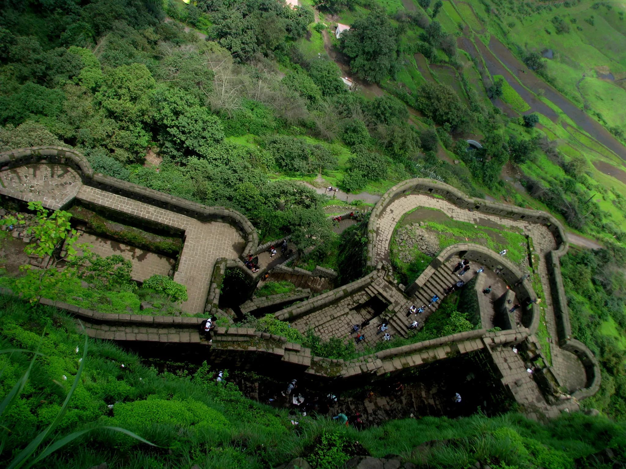
The wind whipped around me, carrying the scent of damp earth and wild grass, as I crested the final rise towards Lohagad Fort. Having explored countless Rajputana strongholds, from the majestic Mehrangarh to the delicate Hawa Mahal, I arrived at this Maratha marvel with a keen eye for comparison, and Lohagad did not disappoint. Unlike the sandstone behemoths of Rajasthan, Lohagad rises from the basalt rock, its dark, rugged ramparts almost merging with the Sahyadri mountains. The fort, strategically perched at an elevation of 3,400 feet, commands breathtaking views of the surrounding valleys, a vista that must have been invaluable to its defenders. The climb itself was invigorating, a winding path leading through dense foliage. The approach, though steep, lacked the elaborate gateways and layered defenses I’m accustomed to seeing in Rajasthan. This speaks volumes about the distinct military philosophies at play. Rajput forts were often designed to impress as much as to defend, showcasing the ruler’s power and wealth. Lohagad, on the other hand, prioritized practicality and strategic advantage. Stepping through the main gate, I was struck by the fort’s understated grandeur. The architecture is starkly functional, devoid of the ornate carvings and intricate jalis that adorn Rajput palaces. The sturdy basalt construction, though lacking the aesthetic flourish of marble, exudes a sense of raw power and resilience. The walls, thick and imposing, still bear the scars of time and conflict, whispering tales of sieges and skirmishes. I spent hours exploring the fort’s extensive ramparts, tracing the lines of its four large gates – Maha Darwaja, Ganesh Darwaja, Narayan Darwaja, and Hanuman Darwaja. Each gate, strategically placed, offered a different perspective on the surrounding landscape. I could almost envision the Maratha soldiers patrolling these walls, their eyes scanning the horizon for approaching enemies. One of the most intriguing aspects of Lohagad is its ingenious water management system. Several large tanks, carved into the rock, collected rainwater, ensuring a continuous supply for the garrison. This foresight, crucial in a region with distinct wet and dry seasons, is a testament to the Maratha’s practical approach to fortification. This contrasts sharply with the elaborate stepwells and baoris of Rajasthan, which, while architecturally stunning, were often more vulnerable to siege tactics. The highlight of my visit was undoubtedly reaching Vinchukata, the highest point of the fort. From this vantage point, the panoramic view stretched across the verdant valleys, encompassing the neighboring Visapur Fort and the winding ribbon of the Indrayani River. It was a vista that captured the strategic brilliance of Lohagad’s location, a natural fortress guarding the vital trade routes. While exploring the fort's interiors, I noticed a distinct lack of opulent palaces or elaborate residential structures. This further reinforced the impression that Lohagad was primarily a military installation, prioritizing function over luxury. The remnants of barracks and storehouses spoke of a disciplined and pragmatic lifestyle, a stark contrast to the lavish courts of Rajputana. Leaving Lohagad, I felt a deep appreciation for its unique character. It was a powerful reminder that strength and resilience can be found not only in ornate grandeur but also in stark simplicity. The fort stands as a testament to the ingenuity and strategic brilliance of the Marathas, a stark contrast yet equally impressive when compared to the majestic forts and palaces I know so well back home in Rajasthan. Lohagad's rugged beauty and strategic significance etched themselves into my memory, a worthy addition to my repertoire of Indian fortifications.
The imposing monoliths of Nartiang Fort, etched against the emerald canvas of Meghalaya's Jaintia Hills, whispered tales of a kingdom long past. Having explored every UNESCO site in India, I can confidently say that Nartiang holds a unique charm, a raw, untamed beauty distinct from the polished grandeur of other historical sites. It's not just a fort; it's a living testament to the strength and resilience of the Jaintia kingdom. My journey to Nartiang began in Jowai, the district headquarters, from where a winding road, flanked by lush greenery and punctuated by cascading waterfalls, led me to this hidden gem. The fort, or what remains of it, isn't a single, cohesive structure. Instead, it's a sprawling complex spread across a gentle slope, comprising remnants of the summer palace, the durbar, and other structures, all interwoven with the local village life. The most striking feature of Nartiang Fort is undoubtedly the collection of imposing monoliths, locally known as 'Moo Shyiap'. These towering stone structures, some reaching heights of over 20 feet, are a testament to the megalithic culture that thrived in this region. Each monolith, erected by past kings to commemorate significant events or victories, stands as a silent sentinel, bearing witness to centuries of history. I spent hours walking amongst them, tracing the weathered surfaces with my fingers, trying to decipher the stories they held. The sheer scale and artistry of these monoliths left me awestruck. They are not merely stones; they are tangible echoes of a powerful past. Beyond the monoliths, the remnants of the fort's structures offer glimpses into the architectural style of the Jaintia kingdom. The crumbling walls, made of locally sourced stone and bound with a mortar that has withstood the test of time, reveal a simple yet robust construction technique. While much of the fort lies in ruins, the layout still suggests a well-planned complex, with designated areas for residential quarters, administrative buildings, and religious structures. I noticed the strategic positioning of the fort, overlooking the valley below, offering a clear vantage point for defense. One of the most intriguing aspects of Nartiang Fort is its integration with the present-day village. Unlike many historical sites that are cordoned off and isolated, Nartiang Fort is very much a part of the living fabric of the community. Houses have sprung up amidst the ruins, children play amongst the monoliths, and daily life unfolds within the shadow of history. This seamless blend of past and present adds a unique dimension to the experience, offering a rare glimpse into the continuity of human settlement in this region. Adjacent to the fort, I discovered the ruins of a Hindu temple dedicated to the goddess Durga. This unexpected find highlighted the religious syncretism that characterized the Jaintia kingdom. The temple, though in ruins, still retains intricate carvings on its stone pillars and doorways, showcasing a blend of local and traditional Hindu architectural styles. It served as a poignant reminder of the cultural exchange and religious tolerance that once flourished in this region. My visit to Nartiang Fort was more than just a sightseeing trip; it was a journey through time. It was a humbling experience to stand amidst these ancient stones, to feel the weight of history, and to witness the enduring spirit of a people who have preserved their heritage despite the passage of time. Nartiang is not a polished, packaged tourist destination; it's a raw, authentic experience that offers a profound connection to the past. It's a place that stays with you long after you've left, a testament to the power of history to inspire and to connect us to our shared human story. If you're seeking a truly unique and enriching historical experience, Nartiang Fort should be on your itinerary.
The wind whipped around me, carrying whispers of history as I stood atop Pratapgad Fort, the very air seeming to vibrate with the echoes of clashing swords and the roar of Maratha war cries. Having explored countless forts across North India, I thought I had become somewhat jaded to the grandeur of ancient stone, but Pratapgad, perched high on the Sahyadri mountains of Maharashtra, proved me wrong. It wasn't just a fort; it was a living testament to the indomitable spirit of Shivaji Maharaj. The ascent itself was an experience. The winding road, clinging to the mountainside, offered breathtaking views of the Konkan plains stretching out below, a tapestry of green punctuated by the silver threads of rivers. As the fort came into view, its imposing basalt ramparts rising against the backdrop of the vast sky, I felt a surge of anticipation. Unlike the sandstone structures I was accustomed to in the north, Pratapgad's dark grey basalt construction lent it a unique, almost brooding aura. The rugged stone, seemingly hewn directly from the mountain itself, spoke of resilience and strength. Passing through the Mahadarwaja, the main gate, I was immediately struck by the fort's strategic design. The thick walls, punctuated by strategically placed bastions and fortified towers, offered a clear view of the surrounding valleys, making it virtually impregnable. Within the fort walls, the atmosphere shifted. The bustling energy of the climb gave way to a sense of quiet reverence. I walked along the ramparts, tracing the path of sentinels who once guarded this stronghold. The views from the top were simply spectacular; the rolling hills, shrouded in mist, seemed to stretch on forever. It was easy to imagine Shivaji Maharaj surveying his domain from this very spot, strategizing his next move. The architecture within the fort was a blend of functionality and subtle artistry. The Bhavani Mata Temple, dedicated to Shivaji's family deity, stood as a beacon of faith within the fortress. Its simple yet elegant design, crafted from the same dark basalt as the fort walls, exuded a quiet strength. The intricate carvings on the pillars and doorways, though weathered by time, still bore witness to the skill of the artisans who built it. One of the most poignant moments of my visit was standing at the site of the historic meeting between Shivaji Maharaj and Afzal Khan. The very ground beneath my feet held the weight of history, a silent witness to the cunning strategy and decisive action that shaped the destiny of the Maratha empire. A small monument marked the spot, a stark reminder of the pivotal events that unfolded here. Exploring the fort's inner chambers, I discovered hidden passages, secret tunnels, and strategically placed water tanks, all testament to the meticulous planning that went into its construction. The Balekilla, the highest point of the fort, offered panoramic views of the surrounding landscape, a breathtaking vista that stretched as far as the eye could see. Leaving Pratapgad was like stepping out of a time capsule. The experience was more than just a visit to a historical site; it was an immersion in the heart of Maratha history. The fort's imposing architecture, its strategic location, and the stories it held within its walls left an indelible mark on me. As I descended the mountain, I carried with me not just photographs and memories, but a deeper understanding of the courage, resilience, and strategic brilliance that shaped the destiny of a nation.
The wind whipped at my kurta as I climbed the final stretch to Purandar Fort, perched high above the sprawling plains surrounding Pune. The air, thin and crisp, carried with it the whispers of history, a palpable sense of the Maratha empire that once commanded these heights. My camera, a constant companion, felt heavy in my hand, almost inadequate to capture the grandeur unfolding before me. Purandar isn't just one fort, but two – Purandar proper and Vajragad, its slightly lower, twin-peaked companion. This duality, this mirroring of structures, immediately captured my attention. The climb itself was a journey through time, the rough-hewn basalt steps worn smooth by centuries of footfalls. I paused often, not just to catch my breath, but to absorb the changing perspectives of the landscape below – the patchwork quilt of fields, the distant glint of the Mula-Mutha river, the tiny villages scattered like pebbles across the valley. Reaching the top, I was greeted by the imposing Kedareshwar Temple, its weathered stone a testament to the passage of time. The intricate carvings, though softened by erosion, still spoke of a skilled hand, a devotion poured into every chisel stroke. Unlike the opulent temples of Madhya Pradesh, this one felt austere, almost military in its simplicity, reflecting perhaps the strategic importance of this location. The fort itself is a fascinating blend of natural defenses and carefully planned fortifications. The steep cliffs form natural ramparts, while the strategically placed bastions and gateways speak of a sophisticated understanding of military architecture. I spent hours exploring the ruins, my lens drawn to the remnants of the past. The crumbling walls, the broken arches, the silent cannons – each element told a story. I was particularly intrigued by the 'Bini Darwaza', a hidden escape route carved into the cliff face. Imagining the hurried footsteps of soldiers and royalty using this secret passage during times of siege sent a shiver down my spine. The view from the ramparts was breathtaking, a panoramic sweep of the surrounding countryside. It was easy to see why this location was so fiercely contested, a strategic vantage point commanding the trade routes and the surrounding territories. The most poignant moment of my visit, however, was at the site of Shivaji Maharaj's son, Sambhaji’s birth. A small, unassuming structure marks the spot, but the historical weight of the location was immense. Here, within these very walls, a key figure in Maratha history was born. It was a humbling experience, a reminder of the human stories woven into the fabric of these ancient stones. As the sun began its descent, casting long shadows across the fort, I made my way down, my memory card filled with images, my mind buzzing with impressions. Purandar is more than just a fort; it's a living testament to the resilience and ingenuity of the Maratha empire. It's a place where history whispers in the wind, where the stones themselves hold memories, and where the landscape unfolds like a tapestry woven with the threads of time. My photographs, I hope, will capture a fraction of this magic, a glimpse into the soul of this magnificent historical site. But the true essence of Purandar, the feeling of standing on the precipice of history, is something that can only be experienced firsthand.
The wind whipped around me, carrying whispers of history as I stood atop Sinhagad Fort, a formidable sentinel overlooking the sprawling landscape below. The ascent itself, a winding road clinging to the Sahyadri hills, had been a prelude to the grandeur that awaited. Having spent years documenting the ancient sites of Madhya Pradesh, I've developed a keen eye for the nuances of historical architecture, and Sinhagad, with its rugged charm and strategic brilliance, immediately captivated me. The fort, originally known as Kondhana, has witnessed centuries of power struggles, its stones absorbing the echoes of Maratha resilience. Standing at the very spot where pivotal battles were fought, I felt a palpable connection to the past. The panoramic view from the ramparts stretched across undulating hills, punctuated by the occasional glint of a distant village. It's easy to see why this location was so fiercely contested – control of Sinhagad meant command over the surrounding valleys and trade routes. The architecture of Sinhagad is a testament to its military purpose. Unlike the ornate palaces I've documented in Mandu, Sinhagad's structures prioritize function over embellishment. The massive walls, built from locally quarried stone, are punctuated by strategically placed bastions and fortified gates. The Kalyan Darwaza and Pune Darwaza, the two main entrances, still bear the scars of past sieges, their thick wooden doors reinforced with iron bands. I spent considerable time photographing these gates, trying to capture the weight of history etched into their weathered surfaces. Within the fort walls, the remnants of various structures paint a picture of life within this military stronghold. The Amruteshwar Temple, a modest stone structure dedicated to Lord Shiva, stands in stark contrast to the surrounding fortifications. Its simple elegance offered a moment of quiet contemplation amidst the echoes of war. I was particularly struck by the intricate carvings on the temple's doorway, a testament to the enduring artistry of the region. The Dev Take, a steep precipice on the eastern side of the fort, offers a breathtaking, if somewhat dizzying, view. Local legend claims that Tanaji Malusare, a celebrated Maratha warrior, scaled this cliff face with the help of a monitor lizard during a daring nighttime raid. Standing at the edge, feeling the wind buffet me, I could almost visualize the scene unfolding centuries ago. One of the most intriguing aspects of Sinhagad is its water management system. Several strategically placed tanks and cisterns, carved into the rock, collected rainwater, ensuring a continuous supply for the fort's inhabitants. This foresight, crucial for withstanding prolonged sieges, speaks volumes about the ingenuity of the fort's builders. I was fascinated by the intricate network of channels and sluices that regulated the flow of water, a testament to the sophisticated engineering of the time. My visit to Sinhagad wasn't just about documenting the physical structures; it was about absorbing the spirit of the place. The fort isn't just a collection of stones and mortar; it's a living testament to human resilience, strategic brilliance, and the enduring power of history. As I descended the winding path, leaving the fort behind, I carried with me not just photographs, but a deeper understanding of the rich tapestry of India's past. The whispers of history, carried on the wind, had found a new echo in my own heart.
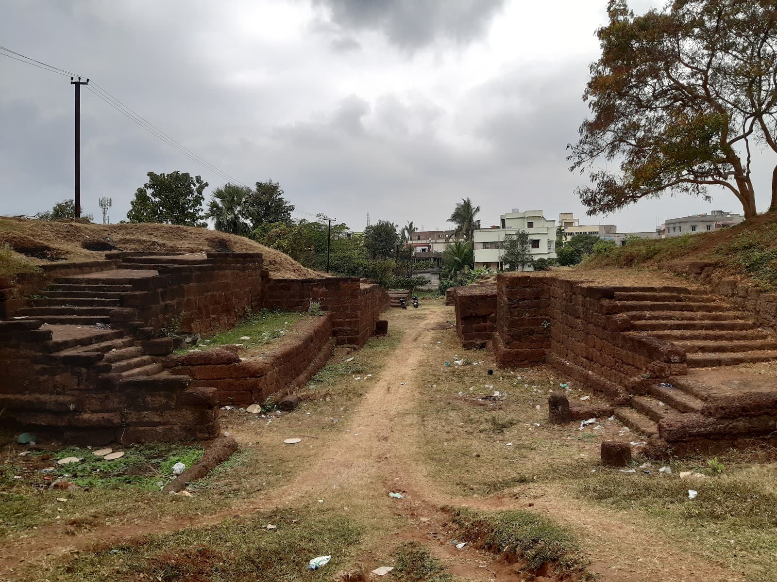
The laterite ramparts of Sisupalgarh rose before me, baked a deep, rusty red under the Odisha sun. Not the imposing, sheer walls of a Rajput fortress, but rather the sprawling, undulating remains of a city fortification, hinting at a life lived within centuries ago. Here, just a few kilometers from the bustling modernity of Bhubaneswar, lay the whispers of ancient Kalinga, a realm steeped in history and architectural ingenuity. My fingers traced the rough texture of the laterite, a porous rock formed from iron-rich soil. Its use spoke volumes about the builders’ resourcefulness and understanding of the local environment. This wasn't just a defensive structure; it was a testament to sustainable building practices, utilizing readily available materials. The ramparts, though eroded by time, still retained a sense of formidable strength. They stretched in a roughly square shape, enclosing an area of approximately 1.2 square kilometers, a scale that impressed upon me the sheer size of this ancient settlement. Walking along the top of the ramparts, I could see the clear demarcation of the moat, now dry and overgrown, but once a crucial defensive feature. The strategic placement of gateways, particularly the impressive northern and southern entrances, suggested a well-planned urban layout. These weren't mere openings; they were carefully constructed passages, designed for both defense and ceremonial processions. I could almost picture the chariots rumbling through, the soldiers standing guard, the vibrant life of the city flowing in and out. Descending into the heart of the fort, I encountered the remnants of what were once bustling streets and residential areas. The foundations of houses, crafted from the same laterite, were still visible, laid out in a grid pattern, indicative of a planned urban settlement. The discovery of artifacts like pottery shards, terracotta figurines, and iron implements during excavations paints a vivid picture of daily life within these walls. It wasn't just a military outpost; it was a thriving urban center, a hub of trade and cultural exchange. One of the most striking features of Sisupalgarh is its sophisticated water management system. Evidence suggests the presence of elaborate drains and reservoirs, showcasing the advanced engineering skills of the time. The careful planning of water resources, crucial in a region with distinct wet and dry seasons, speaks to the foresight and practicality of the city's planners. It’s a reminder that even in ancient times, urban planning considered the practicalities of daily life, not just defense and grandeur. The Ashokan rock edicts discovered nearby, though not within the fort itself, add another layer of historical significance to Sisupalgarh. They suggest that the city, then known as Tosali, was a major administrative center under the Mauryan empire. This connection to one of India’s most influential rulers adds a palpable sense of historical weight to the site. Standing amidst these ruins, I felt a tangible connection to the past, a sense of awe at the ingenuity and resilience of those who built and inhabited this ancient city. Sisupalgarh isn't just a collection of ruins; it's a living testament to the rich tapestry of Indian history. It's a place where the past whispers to the present, offering glimpses into the lives, beliefs, and architectural prowess of a civilization that thrived centuries ago. The site deserves more attention, not just as a historical curiosity, but as a valuable lesson in sustainable urban planning and a reminder of the enduring legacy of ancient India. As I left the fort, the setting sun casting long shadows over the laterite walls, I carried with me a profound sense of wonder and a renewed appreciation for the architectural marvels of ancient India. Sisupalgarh is more than just a fort; it is a time capsule, waiting to be explored and understood.
The laterite walls of Thalassery Fort rose against the Malabar Coast’s emerald-green backdrop, a stark, ochre-red testament to a turbulent past. The humidity hung heavy in the air, a familiar embrace for someone accustomed to the tropical climate of Madhya Pradesh, yet the salty tang of the Arabian Sea was a welcome change. My camera, a constant companion, felt almost weightless in my hand, eager to document the stories whispered by these weathered stones. Thalassery Fort isn’t a sprawling citadel like the ones I’m used to back home. It’s compact, almost square, with surprisingly high walls that command a panoramic view of the coastline. The British East India Company erected this stronghold in 1708, a strategic move to solidify their burgeoning pepper trade. Standing at the ramparts, I could almost visualize the bustling port below, laden with sacks of spice destined for distant shores, the air thick with the aroma of cloves, cinnamon, and of course, black gold – pepper. The laterite, a locally sourced material, gives the fort a unique texture. It’s not the polished sandstone of Gwalior or the intricately carved marble of Mandu. This is a rougher, more utilitarian beauty. The porous laterite blocks, some bleached almost white by the relentless sun and sea spray, others retaining a deep, earthy red, create a fascinating tapestry of colour and texture. I found myself drawn to the subtle variations in the stone, capturing close-ups of the lichen clinging to the shaded crevices, the intricate patterns formed by the weathering, the silent narrative etched by time. The fort’s architecture is a blend of practicality and subtle elegance. The bastions, strategically placed at the corners, offer commanding views of the surrounding area. The arched gateways, though now weathered and worn, still retain a sense of grandeur. I noticed the lack of elaborate ornamentation, a stark contrast to the ornate Mughal architecture I’m familiar with. This simplicity, however, speaks volumes about the fort’s primary function – defense. It’s a structure built for purpose, not for display. Inside the fort, the remnants of the past are scattered like pieces of a forgotten puzzle. The crumbling barracks, the overgrown courtyard, the silent well – each element whispers tales of the soldiers who lived and fought within these walls. I spent hours exploring these spaces, my camera capturing the interplay of light and shadow, trying to piece together the fragments of history. The light in Kerala is different, softer somehow, and it cast a unique glow on the ruins, lending them an almost ethereal quality. One of the most striking features of Thalassery Fort is its location. Unlike many inland forts, this one sits right on the edge of the sea. The rhythmic crashing of the waves against the base of the walls creates a constant soundtrack, a reminder of the fort’s maritime significance. I walked along the ramparts, the sea breeze whipping through my hair, and imagined the ships arriving and departing, the cannons roaring, the cries of the sailors echoing across the water. The fort is not merely a historical relic; it's a living entity, intertwined with the fabric of the town. Local fishermen dry their nets on the rocks below, children play cricket in the shadow of the walls, and families gather in the evenings to enjoy the cool sea breeze. This seamless integration of the past and the present is what truly captivated me. It’s a testament to the fort’s enduring presence in the community. Leaving Thalassery Fort, I felt a sense of connection, not just to the site itself, but to the people whose lives have been touched by its presence. My camera, now heavy with images, felt like a repository of stories, waiting to be shared. The laterite walls, bathed in the golden light of the setting sun, seemed to wave goodbye, a silent promise of a return visit.
Related Collections
Discover more heritage sites with these related collections
Explore More Heritage
Explore our comprehensive documentation of these 11 heritage sites, featuring architectural analysis, historical context, visitor information, conservation status, and detailed site-specific resources supporting meaningful engagement with India's living heritage traditions.
Historical Context
Understanding the historical context of these 11 heritage sites illuminates centuries of Hindu architectural achievement and spiritual devotion. Across successive dynasties, royal patrons and spiritual communities collaborated to create these magnificent monuments as expressions of dharmic duty and devotional fervor. Multiple dynasties contributed distinctive architectural visions, engaging master architects (sthapatis), skilled sculptors (shilpis), and specialized craft guilds who transmitted knowledge through generations. These collaborations produced monuments reflecting both royal vision and artisan mastery, incorporating ancient Vedic principles with regional innovations. Archaeological and epigraphic research continues revealing fascinating details about construction processes, guild organization, material sourcing, and patronage networks. Foundation inscriptions, donor records, and architectural evidence illuminate the devotion, resources, and expertise invested in creating these sacred spaces that honor the divine while demonstrating human achievement at its finest.
Architectural Significance
The architectural elements visible across these 11 heritage sites demonstrate the sophisticated synthesis of aesthetic beauty, structural engineering, and spiritual symbolism characteristic of Hindu temple architecture. The fortification architecture style tradition expresses itself through distinctive features: distinctive regional architectural elements, spatial planning principles, and decorative vocabularies. Indigenous building materials—locally sourced stone, traditional lime mortars, timber where appropriate—shaped architectural possibilities and aesthetic expressions. Monumental scale creates appropriate awe, preparing visitors psychologically for divine encounter. Intricate sculptural programs covering every surface teach Puranic narratives and iconographic conventions, transforming architecture into pedagogical instruments. Structural innovations—corbelling achieving remarkable cantilevers, domed ceilings distributing forces through hidden interlocking systems—demonstrate engineering knowledge refined through centuries of practical experience. Lighting conditions dramatically affect sculptural perception; morning and evening illumination reveals details obscured during harsh midday sun. Advanced documentation through photogrammetry and laser scanning continues discovering previously unrecorded architectural elements, enriching scholarly understanding of these magnificent achievements.
Conservation & Preservation
The preservation status of these 11 heritage sites reflects ongoing commitment to safeguarding India's irreplaceable heritage. While protection mechanisms vary, ensuring legal safeguards and systematic conservation programs. Challenges include environmental factors, material degradation, and visitor management. Professional conservation employs traditional techniques alongside modern technology: structural monitoring, condition assessments, and preventive measures addressing deterioration before critical failures occur. Advanced documentation—aerial surveys, laser scanning, material analysis—creates comprehensive records supporting evidence-based interventions. Visitor participation in heritage preservation includes respectful site conduct, reporting observed damage, and supporting conservation initiatives financially. The investment in documentation and monitoring ensures that when intervention becomes necessary, restoration maintains historical authenticity and technical compatibility with original construction methods.
Visitor Information
Planning visits to these 11 heritage sites benefits from understanding access logistics and appropriate conduct. India offers well-developed infrastructure with accommodation options available near major heritage sites. The optimal visiting season extends October through March. Entry fees at protected sites typically range ₹25-₹40. Photography for personal use is generally permitted, though tripods and professional equipment may require advance authorization. Respectful conduct honors both the monuments and continuing worship traditions: modest attire with covered shoulders and legs, shoe removal in temple sanctums, quiet demeanor, and abstaining from touching sculptural surfaces. Knowledgeable local guides enhance understanding of architectural features, iconographic programs, and ritual contexts, transforming visits into meaningful cultural experiences.
Key Facts & Statistics
Total documented heritage sites: 11
Monument: 8 sites
Fort: 3 sites
Ahom architecture style, Assamese Vernacular architecture style, Fortification architecture style, Hindu Temple architecture style architectural style: 1 sites
Maratha Fortification architecture style, Deccani Sultanate architecture style, Rajput Military architecture style, Nagara architecture style architectural style: 1 sites
Maratha Fortification architecture style, Indo-Islamic architecture style, Rajput Military architecture style, Hill Fort architecture style architectural style: 1 sites
Maratha Fortification architecture style, Deccani Military architecture style, Rajput Military architecture style, Hemadpanti architecture style architectural style: 1 sites
Tai Ahom architecture style, Nagara architecture style, Kalinga architecture style, Fortification architecture style architectural style: 1 sites
Maratha Period period construction: 5 sites
Ahom Period period construction: 3 sites
British Colonial Period period construction: 2 sites
Mahajanapada Period period construction: 1 sites
Average documentation completion score: 80%
Featured flagship heritage sites: 11
Comprehensive digital archiving preserves heritage for future generations
Comprehensive digital archiving preserves heritage for future generations
Comprehensive digital archiving preserves heritage for future generations
Comprehensive digital archiving preserves heritage for future generations
Comprehensive digital archiving preserves heritage for future generations
Comprehensive digital archiving preserves heritage for future generations
Frequently Asked Questions
How many heritage sites are documented in India?
This collection includes 11 documented heritage sites across India. Each site has comprehensive documentation including photos, floor plans, and historical research.
What is the best time to visit heritage sites in India?
October through March is ideal for visiting heritage sites in India. Major festivals also offer unique cultural experiences. Check individual site pages for specific visiting hours and seasonal closures.
What are the entry fees for heritage sites?
Protected monuments typically charge ₹25-₹40. State-protected sites often have lower or no entry fees. Many temples and religious sites are free. Children often enter free. Still photography is usually included; video may require additional permits.
Are photography and videography allowed at heritage sites?
Still photography for personal use is generally permitted at most heritage sites. Tripods, flash photography, and commercial filming usually require special permissions. Some sites restrict photography of murals, sculptures, or sanctums. Drones are prohibited without explicit authorization. Always respect signage and guidelines at individual monuments.
Are these heritage sites wheelchair accessible?
Accessibility varies significantly. Major UNESCO sites and recently renovated monuments often have ramps and accessible facilities. However, many historical structures have steps, uneven surfaces, and narrow passages. Contact site authorities in advance for specific accessibility information. Our site pages indicate known accessibility features where available.
Are guided tours available at heritage sites?
Licensed guides are available at most major heritage sites, typically charging ₹200-₹500 for 1-2 hour tours. ASI-approved guides provide historical and architectural insights. Audio guides are available at select UNESCO sites. Our platform offers virtual tours and detailed documentation for major monuments.
What is the conservation status of these heritage sites?
Many sites are protected under heritage conservation laws. Active conservation includes structural stabilization, surface cleaning, vegetation control, and drainage management. Digital documentation helps monitor deterioration. Ongoing surveys track condition changes for evidence-based interventions.
What are the key features of fortification architecture style architecture?
Fortification architecture style architecture features distinctive regional architectural elements, spatial planning principles, and decorative vocabularies. These elements evolved over centuries, reflecting regional climate, available materials, construction techniques, and cultural preferences. Each monument demonstrates unique variations within the broader architectural tradition.
What documentation is available for these heritage sites?
Each site includes high-resolution photography, architectural measurements, historical research, and expert annotations. Documentation averages 80% completion.
How much time should I allocate for visiting?
Plan 2-3 hours for major monuments to appreciate architectural details and explore grounds. Smaller sites may require 30-60 minutes. Multi-site itineraries should allocate travel time. Early morning or late afternoon visits offer better lighting for photography and fewer crowds. Check individual site pages for recommended visiting durations.
What is the cultural significance of these heritage sites?
These monuments represent India's diverse cultural heritage, reflecting centuries of architectural innovation, religious traditions, and artistic excellence. They serve as living links to historical societies, preserving knowledge about construction techniques, social structures, and cultural values. Many sites remain active centers of worship and community gathering.
How can I practice responsible heritage tourism?
Respect site rules including photography restrictions and designated pathways. Don't touch sculptures, murals, or walls. Dispose waste properly. Hire local guides to support communities. Avoid visiting during restoration work. Learn about cultural contexts before visiting. Report damage to authorities. Your responsible behavior helps preserve heritage for future generations.
References & Sources
Fortification Architecture Style
Fortification Architecture Style architecture is a distinctive style of Indian temple architecture characterized by its unique design elements and construction techniques. This architectural tradition flourished in India and represents a significant period in Indian cultural heritage. Features include intricate carvings, precise proportions, and integration with religious symbolism.
- 1Diverse architectural styles from various periods
- 2Intricate craftsmanship and artistic excellence
- 3Historical and cultural significance
- 4Well-documented heritage value
- 5Protected under heritage conservation acts
- 6Tourist and educational significance
| 📍Maharashtra | 4 sites |
| 📍Goa | 2 sites |
| 📍Assam | 1 sites |
| 📍Arunachal Pradesh | 1 sites |
| 📍Meghalaya | 1 sites |
| 📍Kerala | 1 sites |
| 📍Odisha | 1 sites |