Kerala
Fort
2 sites
📍 11.8024°N, 75.4166°E
Fort Near Kannur
Architectural photography of fort near Kannur requires technical knowledge of lighting, compositional principles, and site-specific protocols. These 2+ monuments present exceptional photographic subjects featuring intricate sculptural details, dramatic architectural forms, and complex light-shadow interactions. Success depends on timing: early morning and late afternoon illumination enhance sculptural relief and architectural details, while midday conditions may present challenges. Our documentation addresses optimal photography timing, equipment considerations (tripod restrictions, lens recommendations), permission requirements distinguishing personal from professional photography, and site-specific restrictions regarding flash usage, video recording, and commercial applications. Understanding these protocols before arrival prevents disappointment and ensures respectful documentation practices. This resource serves professional photographers, architectural documentarians, and serious enthusiasts requiring technical information supporting high-quality visual documentation of Kerala's significant architectural heritage.
About Kannur Heritage Region
Kannur occupies a heritage-rich region of Kerala, reflecting historical importance rooted in geographical advantages, pilgrimage networks, and royal patronage traditions. The concentration of fort throughout this region developed through centuries of religious devotion, political power, and cultural achievement. Sites range from locations within Kannur proper to monuments situated 30-90 minutes distant, enabling both brief visits and comprehensive day-long explorations. Accessible sites facilitate morning visits returning by afternoon, while more distant monuments reward full-day excursions potentially combining multiple sites along geographical routes. Transportation infrastructure throughout Kannur includes app-based ride services, traditional auto-rickshaws, and taxi services. Multiple-site visits often benefit from private vehicle hire enabling flexible scheduling and optimal route planning. Visiting patterns vary seasonally and weekly; weekday mornings typically offer peaceful experiences, while festival periods provide opportunities to witness continuing traditions, though with increased visitor density. This collection documents prominent sites alongside lesser-known monuments, enabling balanced itineraries combining well-documented heritage with discoveries off typical tourist circuits.
Getting Around from Kannur
Transportation from Kannur to regional heritage sites employs various modalities depending on distance and infrastructure. Sites within Kannur limits remain accessible via auto-rickshaws or app-based ride services (Ola, Uber where available). Outlying monuments require private vehicle access: rental cars for independent travelers comfortable with regional driving conditions, or hired vehicles with experienced drivers (approximately ₹2,000-3,500 daily, varying by distance and vehicle type). Public bus services provide economical alternatives though requiring familiarity with local transport systems. Organized tours offer structured itineraries with less scheduling flexibility. Distance ranges span 5-80 kilometers from Kannur; proximate sites (5-15km) involve 30-45 minute journeys, while more distant monuments (40-80km) require 1.5-2.5 hours depending on traffic conditions and road quality. Site-specific documentation provides exact coordinates, suggested routes, and access considerations. Local knowledge complements digital navigation; consulting residents regarding road conditions and optimal routes proves valuable.
When to Visit
Seasonal considerations significantly affect heritage site visiting experiences throughout Kerala. The optimal period extends from October through March, offering comfortable temperatures (15-28°C), minimal precipitation, and extended visiting hours, though popular sites experience higher visitor density. Summer months (April-June) present challenging temperatures (35-45°C) necessitating early morning or late afternoon visits, particularly at sites lacking substantial shade coverage. Reduced visitor numbers during this period offer quieter experiences for those accommodating temperature extremes. Monsoon season (July-September) transforms landscapes dramatically with lush vegetation and atmospheric conditions, though precipitation may limit outdoor activities and render certain routes temporarily inaccessible. Most fort remain accessible year-round, though specific closures or modified hours warrant verification. Shoulder months (October, March) optimize weather comfort with moderate visitor levels. Festival periods at active worship sites provide enriching cultural experiences, though with substantially increased attendance meriting advance planning.
Quick Facts
•2 fort within reach of Kannur
•Located in Kerala, a state rich in cultural heritage
•Average travel time: 30-90 minutes from Kannur city center
•Best visiting season: October to March for optimal weather
•Entry fees range from free to ₹600 depending on site protection status
•Most sites are accessible by taxi, auto-rickshaw, or private vehicle
•GPS coordinates provided for all sites for accurate navigation
•Local guides available at major heritage sites (₹200-500 per tour)
•Photography permitted at most sites (tripod restrictions may apply)
•Kannur serves as convenient base with hotels and restaurants
•Weekend trips and day excursions easily planned from Kannur
•Documentation includes current timings, updated regularly
•Many sites within 30km radius of Kannur city center
•ASI-protected sites maintain year-round accessibility (except Fridays)
•Monsoon season (July-Sept) may affect accessibility to certain sites
Common Questions
How many fort are near Kannur?
There are 2 documented fort within easy reach of Kannur. Distances range from within the city to about 80km out. Most are accessible as day trips.
What's the best way to reach fort from Kannur?
Hire a car with driver for the day (₹2000-3500) for multiple sites. For single sites, use app cabs or auto-rickshaws. Local buses work but require time and patience. Many sites have parking facilities.
When is the best time to visit fort near Kannur?
October to March offers pleasant weather (15-28°C). April-June is very hot. Monsoon (July-Sept) brings rain but fewer crowds. Early morning (6-9am) or late afternoon (4-6pm) have best light and fewer visitors.
How much time do I need to visit fort near Kannur?
Budget 2-3 hours per major site including travel time. Small sites need 45-60 minutes. For a day trip from Kannur, you can comfortably visit 2-3 nearby sites if they're clustered.
What are the entry fees for fort near Kannur?
ASI-protected sites charge ₹25-40 (Indians) and ₹250-600 (foreigners). State-protected and religious sites often have free or nominal entry. Some places charge extra for cameras. Check individual site pages for exact fees.
Can I visit multiple fort in one day from Kannur?
Yes, especially if you hire a car for the day. Group sites by proximity—many are clustered. Start early (7am), prioritize must-sees, and plan routes efficiently. Combining 2-4 sites in a day is realistic.
Are there guided tours available from Kannur?
Yes, tour operators in Kannur offer heritage packages. Private tours provide flexibility. Group tours are cheaper but fixed schedules. Or hire a driver and use our site guides for DIY touring.
Is photography allowed at fort near Kannur?
Personal photography is generally permitted. Tripods often restricted. Flash banned near paintings and murals. Video may need extra permission. Commercial photography requires ASI permits. Drones prohibited without authorization.
What should I wear when visiting fort?
Comfortable walking shoes essential. Cover shoulders and knees at religious sites. Remove shoes inside temples. Light cotton clothes for hot weather. Carry sun protection and water. Dress respectfully—many are active worship places.
Are fort wheelchair accessible?
Accessibility varies. UNESCO sites and recently renovated monuments often have ramps. Many historical structures have steps and uneven surfaces. Check individual site pages for specific accessibility information.
Sources & References
Access comprehensive photographic and technical documentation for 2+ heritage sites near Kannur, including optimal timing, equipment recommendations, permission requirements, and site-specific guidelines supporting professional architectural photography and respectful heritage documentation.
Fort in Kannur
TI
Team Inheritage
Heritage Contributor
St. Angelo Fort Kannur
Puthuvalappu, Kannur, Kannur (670001), Kerala, India
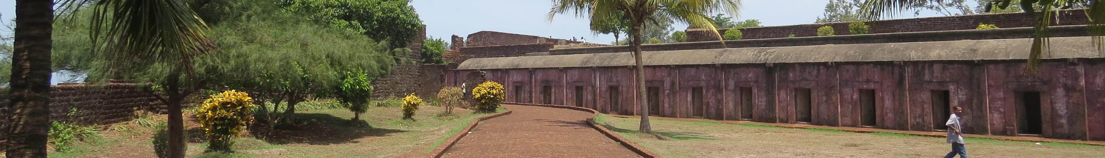
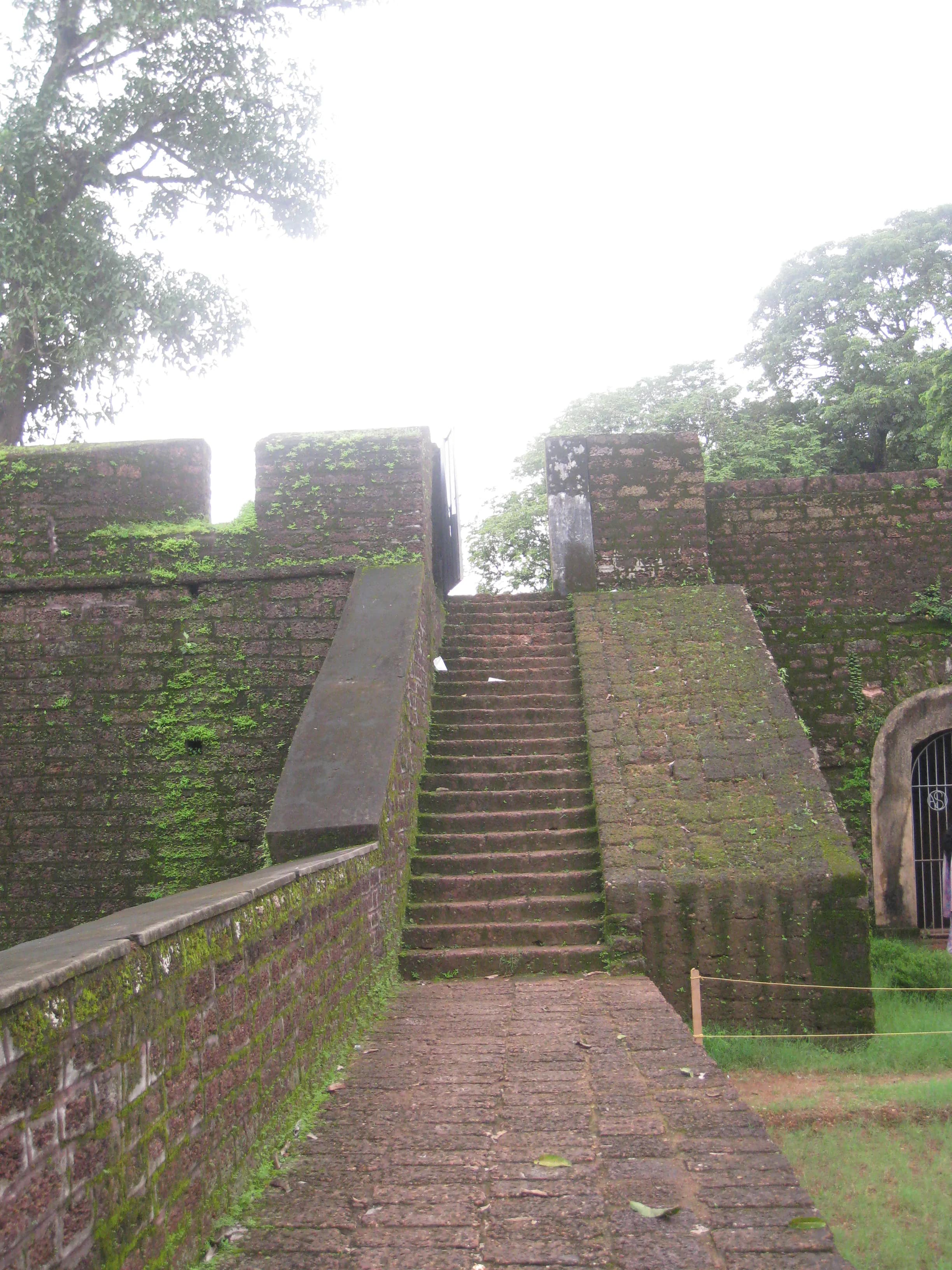
The Arabian Sea roared a salty welcome as I approached St. Angelo Fort, its laterite ramparts rising like a burnt-orange titan against the cerulean canvas. This isn't just a fort; it's a palimpsest of history, etched with the narratives of the Kolathiris, the Portuguese, the Dutch, and the British. Coming from Gujarat, where the architectural language speaks of intricate carvings and sandstone grandeur, the stark, almost brutalist aesthetic of St. Angelo was a striking contrast. The fort’s triangular footprint, dictated by the dramatic headland jutting into the sea, is a masterclass in strategic design. The Portuguese, who began construction in 1505, clearly understood the lay of the land. Every bastion, every curtain wall, is positioned to maximize defensive capabilities. As I walked along the ramparts, the wind whipping through the embrasures, I could almost hear the echoes of cannons and the clash of swords. Unlike the ornate fortifications of Gujarat, St. Angelo’s strength lies in its sheer imposing mass and strategic placement. The laterite stone, so characteristic of Kerala's coastal architecture, lends the fort a unique texture. The warm, earthy hues, punctuated by the verdant green of the overgrowth clinging to the walls, created a visual tapestry that was both rugged and beautiful. I ran my hand over the rough-hewn stone, imagining the generations of hands that had shaped these very walls. The craftsmanship, while different from the precise carvings of Gujarat's stepwells, spoke of a different kind of artistry – one born of necessity and ingenuity. Entering through the arched gateway, I was struck by the remnants of European influence. The double moat, a classic European defensive feature, is remarkably well-preserved. The remnants of the lighthouse, though now just a truncated tower, hinted at the fort's importance as a maritime hub. I noticed the subtle shifts in architectural style, a testament to the fort’s changing hands. The Dutch, who took control in 1663, left their mark with modifications to the bastions and the addition of warehouses. Later, the British further adapted the fort to their needs, adding barracks and administrative buildings. This layering of architectural styles, like the strata of a geological formation, tells a compelling story of conquest and adaptation. The seaward bastions offer breathtaking panoramic views. From the ramparts, I could see the waves crashing against the rocks below, the fishing boats bobbing in the distance, and the coastline stretching out like an emerald ribbon. It's easy to see why this location was so fiercely contested. Control of St. Angelo meant control of the lucrative spice trade and strategic dominance over the Malabar Coast. One of the most intriguing aspects of St. Angelo is the presence of hidden tunnels and secret passages. While many are now inaccessible, the very thought of these subterranean networks sparked my imagination. I pictured clandestine meetings, smuggled goods, and daring escapes – stories whispered through the ages. This element of mystery, absent in the more open and accessible forts of Gujarat, adds a layer of intrigue to St. Angelo. As I left the fort, the setting sun casting long shadows across the ramparts, I felt a sense of awe and respect for this enduring monument. St. Angelo is more than just bricks and mortar; it’s a living testament to the ebb and flow of history, a silent witness to the ambitions and struggles of empires. It stands as a powerful reminder that even the most formidable fortifications are ultimately subject to the relentless march of time. The experience was a stark contrast to the architectural marvels I’ve documented in Gujarat, yet equally captivating, reminding me of the diverse and rich tapestry of India's architectural heritage.
TI
Team Inheritage
Heritage Contributor
Thalassery Fort Thalassery
Mudukkara Road, Kannur, Thalassery (670101), Kerala, India
The laterite walls of Thalassery Fort rose against the Malabar Coast’s emerald-green backdrop, a stark, ochre-red testament to a turbulent past. The humidity hung heavy in the air, a familiar embrace for someone accustomed to the tropical climate of Madhya Pradesh, yet the salty tang of the Arabian Sea was a welcome change. My camera, a constant companion, felt almost weightless in my hand, eager to document the stories whispered by these weathered stones. Thalassery Fort isn’t a sprawling citadel like the ones I’m used to back home. It’s compact, almost square, with surprisingly high walls that command a panoramic view of the coastline. The British East India Company erected this stronghold in 1708, a strategic move to solidify their burgeoning pepper trade. Standing at the ramparts, I could almost visualize the bustling port below, laden with sacks of spice destined for distant shores, the air thick with the aroma of cloves, cinnamon, and of course, black gold – pepper. The laterite, a locally sourced material, gives the fort a unique texture. It’s not the polished sandstone of Gwalior or the intricately carved marble of Mandu. This is a rougher, more utilitarian beauty. The porous laterite blocks, some bleached almost white by the relentless sun and sea spray, others retaining a deep, earthy red, create a fascinating tapestry of colour and texture. I found myself drawn to the subtle variations in the stone, capturing close-ups of the lichen clinging to the shaded crevices, the intricate patterns formed by the weathering, the silent narrative etched by time. The fort’s architecture is a blend of practicality and subtle elegance. The bastions, strategically placed at the corners, offer commanding views of the surrounding area. The arched gateways, though now weathered and worn, still retain a sense of grandeur. I noticed the lack of elaborate ornamentation, a stark contrast to the ornate Mughal architecture I’m familiar with. This simplicity, however, speaks volumes about the fort’s primary function – defense. It’s a structure built for purpose, not for display. Inside the fort, the remnants of the past are scattered like pieces of a forgotten puzzle. The crumbling barracks, the overgrown courtyard, the silent well – each element whispers tales of the soldiers who lived and fought within these walls. I spent hours exploring these spaces, my camera capturing the interplay of light and shadow, trying to piece together the fragments of history. The light in Kerala is different, softer somehow, and it cast a unique glow on the ruins, lending them an almost ethereal quality. One of the most striking features of Thalassery Fort is its location. Unlike many inland forts, this one sits right on the edge of the sea. The rhythmic crashing of the waves against the base of the walls creates a constant soundtrack, a reminder of the fort’s maritime significance. I walked along the ramparts, the sea breeze whipping through my hair, and imagined the ships arriving and departing, the cannons roaring, the cries of the sailors echoing across the water. The fort is not merely a historical relic; it's a living entity, intertwined with the fabric of the town. Local fishermen dry their nets on the rocks below, children play cricket in the shadow of the walls, and families gather in the evenings to enjoy the cool sea breeze. This seamless integration of the past and the present is what truly captivated me. It’s a testament to the fort’s enduring presence in the community. Leaving Thalassery Fort, I felt a sense of connection, not just to the site itself, but to the people whose lives have been touched by its presence. My camera, now heavy with images, felt like a repository of stories, waiting to be shared. The laterite walls, bathed in the golden light of the setting sun, seemed to wave goodbye, a silent promise of a return visit.
Ready to Explore?
Access comprehensive photographic and technical documentation for 2+ heritage sites near Kannur, including optimal timing, equipment recommendations, permission requirements, and site-specific guidelines supporting professional architectural photography and respectful heritage documentation.
City
Kannur
State
Kerala
Total Sites
2
Category
Fort
What is Heritage Sites Near Kannur, Kerala?
Discover 2 documented heritage sites within Kannur, Kerala. From ancient temples to historic forts, explore cultural treasures near you with complete visitor information, GPS coordinates, timings, and directions. Each site includes 3D documentation, historical research, and insider tips for the best visiting experience.
City:
KannurState:
KeralaTotal Sites:
2Category:
FortCoordinates:
11.8024°N, 75.4166°EHow to Explore Heritage Sites in Kannur
- 1
Browse Sites on Map
View all 2 heritage sites in Kannur on our interactive map with real-time distances and GPS coordinates. Filter by category, period, or style.
- 2
Check Visitor Information
Review opening hours, entry fees, best times to visit, and accessibility information for each site. Get insider tips for photography and local guides.
- 3
Plan Your Heritage Trail
Use GPS coordinates and transportation guides to plan your route. Group nearby sites for efficient exploration. Download offline maps for navigation.
- 4
Visit and Document
Follow our visitor guides, respect heritage sites, and capture memories. Share your photos and contribute to our growing documentation.
Planning Your Heritage Trail
| Location | Kannur, Kerala |
| Sites Available | 2 heritage sites documented |
| Transportation | Metro, Bus, Auto, Taxi, Private Vehicle |
| Best Time | October to March (Winter season) |
| Duration | 2-3 hours per site recommended |
| Navigation | GPS coordinates provided for all sites |